← Questions for Brent and Lisa

Older report example · current status not confirmed

Florida's Turnpike from South of Kissimmee Park Road to US 192

FDOT project 441224-1

Osceola PD&E conceptual stage relocation plan 4 properties named in the source

What is known: This 2020 FDOT planning report names four potential relocations and supplies affected-property maps. The related Turnpike widening is now under construction through 2030; whether each 2020 relocation lead remains current still needs to be checked.

What this older report shows

Four properties named in a 2020 planning report

The report provides addresses, property uses, and maps. Current county records identify the owners in the retrieved snapshot. Because the related widening is now under construction, this example is for evaluating the usefulness of older project information—not for immediate outreach.

Potential leads in report
4
Supporting official maps
2
Current owner records found
4 of 4
Draft available for review
1
Still unknown
Current status of each acquisition lead and amount of land affected

Properties named in the FDOT report

2020 property information beside the current county owner

Use these as research leads, not as proof of a current or final acquisition.

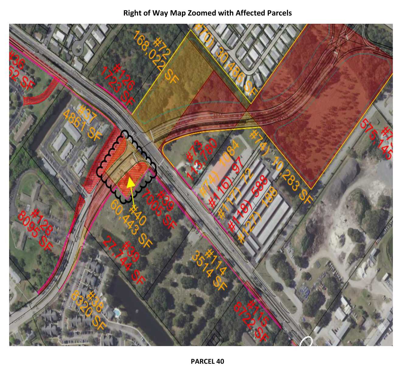
Official FDOT right-of-way map showing parcel labels 40 and proposed roadway acquisition hatching

Map parcel 40

3601 Old Canoe Creek Road, Saint Cloud, FL 34769

2020 official source: Glacial Hope, LLC / 7-Eleven Convenience Store · Potential business displacement

Current county ownerSTATE OF FLA DOT
Current acquisitionNot confirmed

The frozen current county record lists State of Florida DOT, not the 2020 source-era business name.

See the county record and source pages
Current parcel ID
1626300757000100E0
Property appraiser ID
16-26-30-0757-0001-00E0
Current mailing address
FLORIDAS TURNPIKE ENTERPRISE, MILEPOST 263 BLDG 5315, PO BOX 613069, OCOEE FL 34761
County record updated
2026-07-31T15:24:28Z
Source record evidence
PDF pages 21, 29
County match rule
Exactly one candidate with the source house number, street suffix RD, and street-name tokens CANOE and CREEK; OLD is optional because the current 2901 county record omits it.
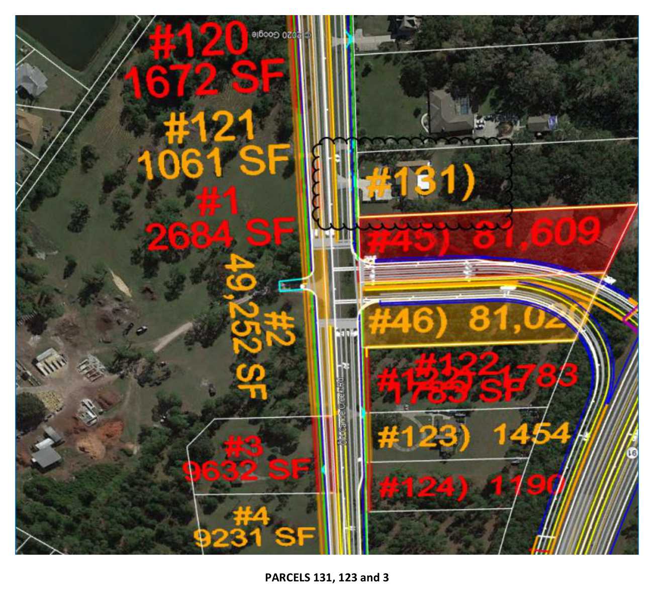
Official FDOT right-of-way map showing parcel labels 131 and proposed roadway acquisition hatching

Map parcel 131

2901 Old Canoe Creek Road, Saint Cloud, FL 34772

2020 official source: Silver Creek Assisted Living · Potential residential / assisted-living displacement

Current county ownerCIRCLE K STORES INC
Current acquisitionNot confirmed

The county road name omits “Old”; the unique matching Canoe Creek Road record is shown.

See the county record and source pages
Current parcel ID
232630072500010400
Property appraiser ID
23-26-30-0725-0001-0400
Current mailing address
PO BOX 52085 DC-17, PHOENIX AZ 85072-2085
County record updated
2026-07-31T15:33:35Z
Source record evidence
PDF pages 13, 30
County match rule
Exactly one candidate with the source house number, street suffix RD, and street-name tokens CANOE and CREEK; OLD is optional because the current 2901 county record omits it.
Official FDOT right-of-way map showing parcel labels 123 and proposed roadway acquisition hatching

Map parcel 123

2950 Old Canoe Creek Road, Saint Cloud, FL 34772

2020 official source: Source-era residential owner · Potential residential displacement

Current county ownerCORDERO YOCALI
Current acquisitionNot confirmed

The current county owner is Yocali Cordero; the 2020 source does not establish current acquisition status.

See the county record and source pages
Current parcel ID
162630547300010230
Property appraiser ID
16-26-30-5473-0001-0230
Current mailing address
2950 OLD CANOE CREEK RD, SAINT CLOUD FL 34772
County record updated
2026-07-31T15:30:16Z
Source record evidence
PDF pages 13, 31
County match rule
Exactly one candidate with the source house number, street suffix RD, and street-name tokens CANOE and CREEK; OLD is optional because the current 2901 county record omits it.
Review property information and draft →
Official FDOT right-of-way map showing parcel labels 3 and proposed roadway acquisition hatching

Map parcel 3

2951 Old Canoe Creek Road, Saint Cloud, FL 34772

2020 official source: Source-era residential owner · Potential residential displacement

Current county ownerEVERS NELDA S
Current acquisitionNot confirmed

The current county owner is Nelda S Evers; the 2020 source does not establish current acquisition status.

See the county record and source pages
Current parcel ID
222630000000500000
Property appraiser ID
22-26-30-0000-0050-0000
Current mailing address
2951 OLD CANOE CREEK RD, SAINT CLOUD FL 34772-7679
County record updated
2026-07-31T15:32:52Z
Source record evidence
PDF pages 13, 32
County match rule
Exactly one candidate with the source house number, street suffix RD, and street-name tokens CANOE and CREEK; OLD is optional because the current 2901 county record omits it.
See how these leads were generated and checked

One official report, checked against current county records

  1. Verify the official PDF, project ID, date, and page count.
  2. Find the affected-property map headings in the PDF text.
  3. Render each official map from its embedded image bounds.
  4. Accept a county identity only when the current service returns one unique address match.

The official records and maps describe a 2020 planning snapshot. County ownership is a separate frozen snapshot, so changes remain visible.

Source identity note: The local discovery corpus called this 438547-1, but the official PDF cover governs and identifies Financial Project 441224-1.

A nearby map parcel was excluded

Parcel 120 appears beside the identified properties, but the report did not name it as a relocation record. The system left it out rather than treating every visible parcel as a lead.

Question for Brent and Lisa

Can an older planning report still produce useful leads?

The related widening is active and the county-owner snapshot is available. Are these 2020 property-specific relocation records still worth researching, or are they too old or incomplete?